|
Each generation moulds and changes the landscape in which it lives, leaving behind its own traces. If this surviving evidence is examined, then archaeologists can begin to unravel the story of the people who used to live here. The humps and hollows that can be seen around the village and especially near the church are quite impressive, but without extensive archaeological excavation their precise history remains a mystery. Presented here are some reconstruction drawings based on the clues taken from translations of medieval documents and from the discoveries at other similar site.
The settlement now known as Castlethorpe is not mentioned by name in William I’s Domesday Survey of 1086. The area which is now the civil parish of Castlethorpe was part of the larger manor of Hanslope during the mediaeval period. The manor and the settlements within it were held by the same lord and would have been farmed communally by the peasants under his control. The Anglo-Saxon place name of Castlethorpe means “the farm or the secondary settlement of the castle” This castle belonging to the lord of Hanslope was certainly in existence by the mid 12th century and may even have been constructed at the end of the previous century.
Before William of Normandy invades England and defeated Harold in 1066, the Saxon lord of the manor of Hanslope was Aldene, who had been a member of the bodyguard of King Edward the Confessor. By this time the English countryside was already organised into distinct areas with fields, woods, and pastures. Many villages were in existence and towns such as Newport Pagnell were functioning as market centres. Although Prehistoric flints and Romano-British metalwork and coins, dating from about AD200, have been found near Castlethorpe village, there is not enough evidence to confirm the existence of a very early settlement here. Only archaeological excavation covering a wide area could perhaps help to determine the origin of the village. William I was crowned in the newly completed Westminster Abbey on Christmas Day 1066. The Saxon landowners were replaced by the new king’s principal Norman supporters and they in turn granted farms and manors to their trusted henchmen. The manor of Hanslope, including the area which was to become known as Castlethorpe, was taken from Aldene and granted to Winemar the Fleming.
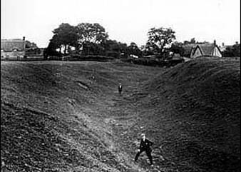
Winemar would have followed William’s policy of keeping a tight control over the Saxons by building himself a manor house (hall) here and defending it was a high bank topped with a stout palisade and a deep ditch, the remains of which we can still see today. His family, household, retainers and servants would have lived as a self-contained unit within this fortified homestead.
During 1138 -1153 many small earthwork castles were built, without Royal licence, as a result of the civil wars known as the Anarchy. These disputes were between King Stephen and his cousin the Empress Matilda, who as the granddaughter of William I, was the rightful heir to the English throne. The existing fortification of Castlethorpe (built about 70 years earlier) may have been strengthened at this time because the Mauduit family, supported the Empress Matilda against King Stephen.
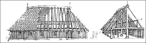
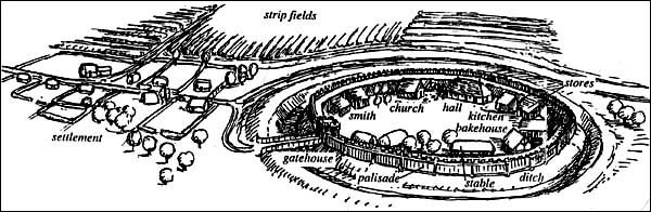
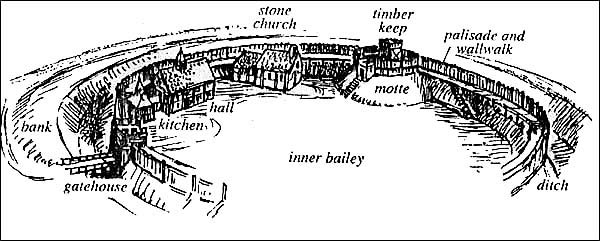
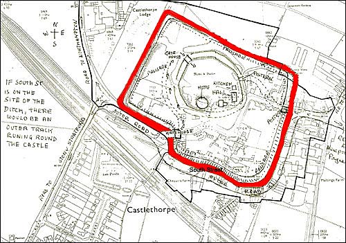
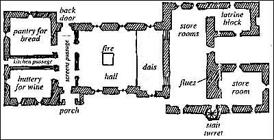
The castle was built on slightly rising ground and would have consisted of a large mound of earth (the motte), toped with a timber tower (the keep), standing at the side of the flat enclosure (the bailey). The motte was probably constructed by deepening the existing ditch and carrying the excavated material to the mound, ramming it down and finishing it off with a layer of smooth clay. William Maudit lived with his family and servants in his hall in the bailey. It was probably a timber building with posts supporting the roof and store rooms for wine, ale and bread next to the entrance. A passageway led to a separate kitchen. The lord and his lady climbed a steep ladder to their chambers above the stores. The bailey also contained the many other timber buildings you can see in the illustrations. Large storehouses were essential, to be filled with supplies in time of danger. The castle survived the Anarchy but seventy years later was put to use once again. Disputes occurred between King John and the increasingly powerful barons and Robert Mauduit was one who joined against the King. The large outer bailey and ditch may have added to the castle as an extra defence at this troubled time. Faulkes de Breaute totally destroyed the castle and gained possession of Hanslope manor but did not choose to live here. Robert Mauduit eventually made his peace with the King and regained the manor before he died in 1222 but the castle was not rebuilt.
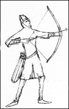
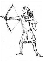
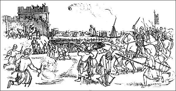
The besieged defended themselves from the palisades with arrows, stones, iron bars, javelins and pots of blazing substances and fought with spears, axes, sharpened staves and spiked clubs once the enemy had broken through. Twisted animal sinews and other materials provided the power for the mediaeval war machines. The catapult flung missiles upwards from the end of a long beam and the ballista fired giant bolts or stones horizontally, but the easiest way to destroy a timber castle was with fire. Rags soaked in inflammable material were attached to arrows and fired from the Norman bow or the cross-bow into the castle timbers. Pots of blazing substances such as sulphur, pitch and naphtha were flung from the trebuchets which worked on a system of counterweights. South Street probably developed later on, along the line of the outer ditch.
The bank that is still visible today around the play area, across the railway footbridge, may be the remains of the southern end of this walled garden. An archaeological excavation was carried out on this bank during 1993, prior to laying a new sewer. The excavation revealed the bank’s structure but not its function. It had, however, constructed on top of a series of earlier medieval features, including a large artificial watercourse which may possibly have taken water away from the defences around the castle. Other medieval features, including pits, were found beyond the area enclosed by the earthworks.
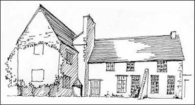
Castle House
|
||||||||||||||||||||||||||||

|